
Hi
it might have been asked before but was wondering if there was a way to cleanup the GPS locations perhaps with Folders where you can label one mining and select them all with one check etc ?
Thanks
Foxz
Introduce Alt-A Select All, Shift-Select, and Ctrl-Select for muti-selecting GPS locations in the GPS Tab menu. This idea is only for the ability to multi-select the locations and set HUD visibility options. When doing this all other fields and options would be greyed out. I'm requesting this because whenever I prospect for ores, I tend to generate a large list of coordinates, and this would speed things up in terms of managing the UI.
 I like this feedback
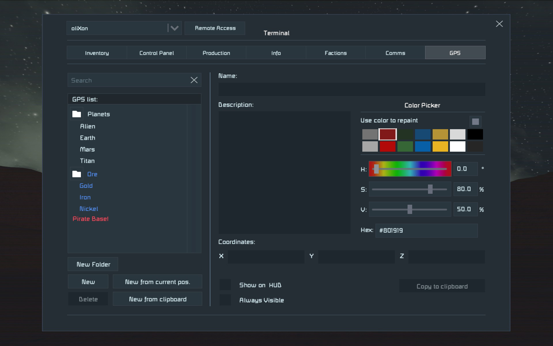
Im adding my ideas:
1) Option to auto turn off GPS locations based on distance
2) Distance value in GPS location detail tab
3) Sorting GPS locations by distance
Im adding my ideas:
1) Option to auto turn off GPS locations based on distance
2) Distance value in GPS location detail tab
3) Sorting GPS locations by distance
Folders for locations will be a good thing too. Imagine having folders "asteroids", "pirate bases", "planets", "my bases"... in your locations tab.
Folders for locations will be a good thing too. Imagine having folders "asteroids", "pirate bases", "planets", "my bases"... in your locations tab.
What about creating groups for GPS locations too, similar to items on the Control Panel?
What about creating groups for GPS locations too, similar to items on the Control Panel?
yeah please add some already in the game functions (like multi-select , groups) to the gps also, it's really bad having like more than 50 gps and always be in the need to scroll through all of them to find specific.
Also I would wish to have some more Icons , currently we only have show on hud and always visible, which gives the icon a little bit difference, but it would be awesome to have some Icons to differentiate more (HQ Symbol,Death Skull Symbol,Numbers as Symbols, etc.)
Also. please add a way to group a collection of GPS points for use as waypoints with the remote control. Thanks!
Also. please add a way to group a collection of GPS points for use as waypoints with the remote control. Thanks!
Folders would do good for multiple things, not just GPS.
https://support.keenswh.com/spaceengineers/general/topic/folders-for-blueprints
Folders would do good for multiple things, not just GPS.
https://support.keenswh.com/spaceengineers/general/topic/folders-for-blueprints
Add custom color choices
Add custom color choices
Ctrl+H key for switching between GPS groups, which would be made the same way as component groups.
Ctrl+H key for switching between GPS groups, which would be made the same way as component groups.
All of the above,. Make it so you can check more than one group and name them how you like. Not just one or all. Just basic example, if I clicked one I could see all the mining facilities I have ores stocked at. If I clicked 1 and 2 I could see which was at or closest to a planet. Then I could use the enemy overlay and see if I may have that to deal with. Of course, it's all up to your imagination. We do need more upvotes!!
O Mining Facilities
O Planet Locations
O Known Hostile Bases
O
This means add 'Toggling Multiple GPS locations on/off for HUD' ? I'm in!
Side topic: for some management tips, this might help someone:
Brenku's GPS Sanity System
I manage my GPS way-points like so:
One asteroid with multiple ores:[Ast] 001 Fe H2 Mg Pt
Or, the same single asteroid with separate ore GPS:
[Ast] 001.a Fe
[Ast] 001.b H2 [Mine]
[Ast] 001.c Mg
[Ast] 001.d Pt
In the new survival version (1.189) asteroids can have many clusters of smaller asteroids around them. So I used that similar style:
Main asteroid[Ast] 001 Fe 1
[Ast] 001 Fe 2
[Ast] 001 Mg 1
[Ast] 001 Pt 1
Small satellite asteroid 1 of Main Asteroid
[Ast] 001.b H2 [Mine]
[Ast] 001.b Ni 1
[Ast] 001.b Ni 2
[Ast] 001.b Si 1
Small satellite asteroid 2 of Main Asteroid
[Ast] 001.c Fe 1
[Ast] 001.c Mg 1
Small satellite asteroid 3 of Main Asteroid
[Ast] 001.d Pt 1
The benefit to the above method, is that I have all my scouted spots and know exactly where things are.
When leaving this area, and scouting more clusters, I can disable on the HUD all of those, except one of them from the Main asteroid. This way, you can see the main asteroid has been discovered/scouted from a distance, but without 10+ other HUDs on the screen. On top of that, if you are looking for a single specific ore, you can simply turn on that one.
Also, I always make a single 'Parking' GPS when I leave a ship. I delete them on leaving the area.
Bases
When it comes to bases/locations, it is similar to the above method.
[Earth] Base 1
[Earth] Ice Lake Base 1
[Earth] Base 1 - Fe Dep 1 (12m)The base and which one is identified (I mean, use a name if you prefer)
The deposit is based on proximity to the base. This way you know it's the iron deposit nearest this specific base. The (12m) is showing you that the deposit found, is 12 meters from the GPS marker. This way you know it's buried for example, and don't need to dig to it or disturb the area if you don't need it then.
Surveying Ores on a planet
If you are scouting and it's not really part of some proximity to a base, I change it slightly:
[Earth] Survey 001 - Fe Dep 1 (10m)
Perhaps you found some other ore next to it?
[Earth] Survey 001 - Mg Dep 1 (Surface)
You are grouping it with survey 001.
Ok, so you are far enough from Survey 001 to make it not close enough to be part of that group?
[Earth] Survey 002 - Si Dep 1 (20m)
Use a new survey number.
Voted, but only if this does not categorically remove modifier keys from being available for assignment to movement.
(Space for Up is OK, but whoever thought that C was a good idea for Crouch or Down should be thrown into the same cell with the guy who thought it was a good idea to use backticks grave accent characters for quoting or formatting, and be punished by having to code on non-QUERTY keyboard layouts for the rest of their life!!)
Some good ideas. I'd also like to see sortable 'Tab' headers at the top of our GPS list, like in a web browser, which we could give names to, like 'Space', 'Earth', 'Mars', etc. Each tag would correspond to the coord location (in space, on Mars et al), allowing us toggle which ones we want to see.
And a 'Select/Deselect All' button.
WHY HASN'T THIS BEEN IMPLEMENTED YET? Been asking for this for a long time!
WHY HASN'T THIS BEEN IMPLEMENTED YET? Been asking for this for a long time!
Vote 100 ! I like these ideas. Folders to organise would be something for me. The TAB idea for instance from punkatron.
Vote 100 ! I like these ideas. Folders to organise would be something for me. The TAB idea for instance from punkatron.
The above is already basically all I want for a more convenient and enjoyable usage of the GPS Tab. Yes Please!
The above is already basically all I want for a more convenient and enjoyable usage of the GPS Tab. Yes Please!
Multi-select exactly as proposed by John would allow us to manually create and show/hide categories, by using a naming scheme and sorting the list by that.
Beyond that we could have category tags in GPS format 2.0: GPS:ISSE Station:seller:12144:35235:12352 (I know it doesn't work, just for illustration) with common categories predefined: seller=ship selling economy station, ore=ore deposit, etc. GPS coordinates from data pads and other players would automatically sort into the corresponding category. A category can be shown/hidden on the HUD like an individual GPS marker and sorting by distance or name is a feature within the categories.
The jump drive would benefit from new hot bar functions "Clear GPS" and "Pick jump target from GPS list" using this improved UI as the current small, unsorted list is difficult to use when you have all the economy stations in your GPS.
Having a distance column in GPS list according to which you can sort (may be a default sort) would help tremendously.
Having a distance column in GPS list according to which you can sort (may be a default sort) would help tremendously.
Agree with grouping gps like in inventory, and having the capacity to sort them by distance or name (wich will be usefull if we name the spots with special rules), and of course the possibility to color them and give them an icon to show on hud. Or to let us put icons in a special game folder to have the icon we want. Brilliant idea you ll had 👍
Agree with grouping gps like in inventory, and having the capacity to sort them by distance or name (wich will be usefull if we name the spots with special rules), and of course the possibility to color them and give them an icon to show on hud. Or to let us put icons in a special game folder to have the icon we want. Brilliant idea you ll had 👍
That would be nice so i don't have to figure out what ones i have on the planet and moon. Its annoying when i look in a direction and see 50+ markers when looking at the planet from the moon and trying to remember what ones to disable.
That would be nice so i don't have to figure out what ones i have on the planet and moon. Its annoying when i look in a direction and see 50+ markers when looking at the planet from the moon and trying to remember what ones to disable.
I strongly support updating the GPS tab!
Folders for cords
Distance from present location to that cord within the GPS tab
I strongly support updating the GPS tab!
Folders for cords
Distance from present location to that cord within the GPS tab
Strong must-have. Voted.
Strong must-have. Voted.
All I want is these simple things.
*Multi Select
*Alphabetical/Distance sort
*Assign Color
*Assign Fade/Hide Distance
*Export/Import All To/From Clipboard/File
All I want is these simple things.
*Multi Select
*Alphabetical/Distance sort
*Assign Color
*Assign Fade/Hide Distance
*Export/Import All To/From Clipboard/File
I want a system where I can custom create Tabs for my GPS markers, like in a web browser, I'd call one Earth for example, or Mars, or Titan, or Deep Space or whatever, and each tab would compartmentalize the markers for only those general areas/territories. I'd be able to show/hide the coords for different tabs based on what I was doing, so if I was working on or around Mars I could show only those markers, hiding all the rest.
I want a system where I can custom create Tabs for my GPS markers, like in a web browser, I'd call one Earth for example, or Mars, or Titan, or Deep Space or whatever, and each tab would compartmentalize the markers for only those general areas/territories. I'd be able to show/hide the coords for different tabs based on what I was doing, so if I was working on or around Mars I could show only those markers, hiding all the rest.
The GPS Tab is long overdue a remake and more user friendly UI.
Some suggestions:
Tabs / Folder System
Sort / Filters
Colouring
Show / hide distance
multi selecting
Being able to link GPS points to Beacons vice versa
Linking beacons / gps with jump drive capabilities
The GPS Tab is long overdue a remake and more user friendly UI.
Some suggestions:
Tabs / Folder System
Sort / Filters
Colouring
Show / hide distance
multi selecting
Being able to link GPS points to Beacons vice versa
Linking beacons / gps with jump drive capabilities
No answer, no ticket change! Push!
No answer, no ticket change! Push!
Yes please, gps is so frustrating to navigate
Yes please, gps is so frustrating to navigate
At least another color than blue. GPS Points have nothing to do with a faction, so they should be white or grey. Not blue!
At least another color than blue. GPS Points have nothing to do with a faction, so they should be white or grey. Not blue!
Hi,
Thanks for the feedback.
Hi,
Thanks for the feedback.
There is a way to share GPS waypoints with factions? This would be nice.
There is a way to share GPS waypoints with factions? This would be nice.
Keen, I beg of you, please do this. Grouping, sorting, batch management... please, please, please!
Keen, I beg of you, please do this. Grouping, sorting, batch management... please, please, please!
Since economy update we need some GPS management. Also it would be nice to have search bar for Jump Drive block
Since economy update we need some GPS management. Also it would be nice to have search bar for Jump Drive block
There is a mod, called EZGPS, that would be a good place to start for adding real GPS management into the vanilla game.
https://steamcommunity.com/sharedfiles/filedetails/?id=1480940163
There is a mod, called EZGPS, that would be a good place to start for adding real GPS management into the vanilla game.
https://steamcommunity.com/sharedfiles/filedetails/?id=1480940163
Love the new color options that been added in game but takes a lot om manuel tinkering. Please add a group option sow you can add a GPS to a group and it gets the coloring for that group and you can show/hide a complete group of GPS with one or two clicks.
Love the new color options that been added in game but takes a lot om manuel tinkering. Please add a group option sow you can add a GPS to a group and it gets the coloring for that group and you can show/hide a complete group of GPS with one or two clicks.
Allow players to create GPS groups and add a GPS to a group and it gets the coloring for that group and you can show/hide a complete group of GPS with one or two clicks.
Allow players to create GPS groups and add a GPS to a group and it gets the coloring for that group and you can show/hide a complete group of GPS with one or two clicks.
I really want the button on the DataPad thingy to do something like place a marker. Using the inventory to place markers is all fine and well, but lacks the immersion of dropping a transmitter (the datapad gets consumed) at a location as an invisible beacon would reduce coordinate spamming surely by having a resource cost?
Right now the place marker button does nothing and should really take you to the inventory tab. The fact that the "hint datapad" you start with in your inventory is not readonly is broken IMHO.
BUMP
BUMP
probably should add the ability to paste in / copy out multiple coordinates at once as well.
probably should add the ability to paste in / copy out multiple coordinates at once as well.
If we could only have one thing being able to shift/ctrl click and ctrl+a on the list of gps cord to be able to edit their color/dispay status in bulk should be it.
then you can just add your own tags to coordinate names, search the tag, ctrl+a to select all the results and toggle show on hud.
The second most important thing would be the ability to copy/paste entire groups of coordinates to allow players to share coordinates in bulk. This can be done by outputting/reading bulk coordinates as a json array.
If we're wishlisting things, I'd like to add named groups of bookmarks so we can enable/disable sets of them more quickly.
If we're wishlisting things, I'd like to add named groups of bookmarks so we can enable/disable sets of them more quickly.
i created an account just to say i always have a lot of coords and need an update that can add folders of coords in GPS
i created an account just to say i always have a lot of coords and need an update that can add folders of coords in GPS
We definitely need this.
We definitely need this.
Id settle for the ability to nest my own GPS tags into a tree/folder system (like groups) so I can hide/show the entire folder/group all at once. Lol
Show and hide by range would also be very nice.
Or auto grouping for markers on a planet, or moon, or section of space, or simply grouped because it’s an ore marker.
If your by an ore, something like /gpsore could automatically add an ‘ore gps’ marker of the detected ore/s for you if your within a few meters of it for example.
Though if you’re going for it, it would also make sense for players to beagle to say.. ‘this is a resource marker’, ‘this is a point of interest’, ‘this is a whatever else’.. Just some definable labels that can be added to each GPS mark individually in addition to being in a tree system. Then players can show only GPS with markers matching this label sort of thing regardless of the tree structure.
Just my thoughts there.
But my goodness some gps management would be good for all lol.
It would be good it we could have shared faction coordinates, like someone finds gold and everybody gets the coordinates automatically
It would be good it we could have shared faction coordinates, like someone finds gold and everybody gets the coordinates automatically
I've been hoping for something like this.
I've been hoping for something like this.
Bump
Bump
If you think my description of this problem on my thread is good, please give it some love: https://support.keenswh.com/spaceengineers/pc/topic/add-full-multiselect-in-the-gps-box
If you think my description of this problem on my thread is good, please give it some love: https://support.keenswh.com/spaceengineers/pc/topic/add-full-multiselect-in-the-gps-box
It would also be really great if they added the ability to create dropdown folders in the GPS menu to better sort all the coordinates. Then you could toggle visibility on a bunch at once.
It would also be really great if they added the ability to create dropdown folders in the GPS menu to better sort all the coordinates. Then you could toggle visibility on a bunch at once.
Even further: actual groups of gps markers. 'asteroids', 'ore deposits', 'nav points', etc., together with characteristics they get for being part of the group. Like colour, visibility. Ranged visibility.
Even further: actual groups of gps markers. 'asteroids', 'ore deposits', 'nav points', etc., together with characteristics they get for being part of the group. Like colour, visibility. Ranged visibility.
Add a further option where you can activate/deactivate whole folders displaying and set the colour for all locations in a folder
Add a further option where you can activate/deactivate whole folders displaying and set the colour for all locations in a folder
Just having the ability to select all (control-A works in other parts of the game) would allow you to copy all your bookmarks for pasting into another application (eg: for posting or sharing without having to make it an LCD or something for the workshop).
Just having the ability to select all (control-A works in other parts of the game) would allow you to copy all your bookmarks for pasting into another application (eg: for posting or sharing without having to make it an LCD or something for the workshop).
Here's a little recap of the past years of comments. Reading through them, we have 4 proposals for how to organize the GPS locations split into two camps:
- Folders (collapsible)
- Tabs (think: browser; can be rearranged and renamed)
- Groups (clone of block groups feature in the terminal)
- Tags
The discrete options aim at an intuitive UI while the overlapping options enable more pro user features through the ability to tag a GPS location as both "iron ore" and "mars" or an NPC station to be "orbit", "moon", "miner". Regardless of organization, players would like to be able to apply bulk operations on GPS locations (color, visibility, deletion, ...).
The set of individual feature wishes for the GPS tab include:
- GPS locations or sets of locations have their own render distance slider
- A global slider applies to all GPS locations not marked "Always visible"
- Name and distance as click-to-sort columns
- Sort by distance from a chosen reference GPS location
- For the folders/tabs approach: A folder/tab can be marked as sort-by-distance, so e.g. closer ores show first
- Tags/folders/tabs/groups can be set to "auto share with faction"; a faction member finds gold ore, adds it to the "ore" folder which automatically updates for the faction
- "Share with faction" button similar to sharing research tree progress
- Cycle through sets, e.g. show "bases", "ores", "traders", ... (works best with folders/tabs approach)
- User can create their own visibility levels adding and subtracting tags/folders/tabs/groups
@developers
After more than 4 years of waiting, the only thing the developers are able to do is to tag this topic as being taken into consideration.
Can you provide more information on when we can expect this long-awaited update with the selection of more GPS coordinates and enable them to be deleted or displayed on the HUD selected?
Thank you,
I use Microsoft excel to manage gps locations. I usually gather about 80 trade station locations per server, and currently have a data base of over 500 asteroid locations. The easiest way to import a massive list of GPS locations into the game is posting it ingot the custome text box of any block that has the option. Unfortunately the game has a limit of 20 gps points you can paste in the GPS menue.
I use Microsoft excel to manage gps locations. I usually gather about 80 trade station locations per server, and currently have a data base of over 500 asteroid locations. The easiest way to import a massive list of GPS locations into the game is posting it ingot the custome text box of any block that has the option. Unfortunately the game has a limit of 20 gps points you can paste in the GPS menue.
I think a good one to do would be to add folders. Some of us have like 50 GPS locations and we struggle to find them when selecting one in a Jump Drive or Autopilot GUI
I think a good one to do would be to add folders. Some of us have like 50 GPS locations and we struggle to find them when selecting one in a Jump Drive or Autopilot GUI
It would help to have folders in the GPS menu to group GPS marks and be able to do settings on whole folders.
It would help to have folders in the GPS menu to group GPS marks and be able to do settings on whole folders.
This is one of the top rated requests and nothing from keen in half a decade.
This also needs a sort by distance. A display of distance, and the ability to assign types.
Types can have a color coding, and a customizable icon. With an option to filter by type.
This is one of the top rated requests and nothing from keen in half a decade.
This also needs a sort by distance. A display of distance, and the ability to assign types.
Types can have a color coding, and a customizable icon. With an option to filter by type.
1. Increase the GPS name and GPS description field size limit. Like twice of current size limit. Purpose: to list all ores in the asteroid or mine in the name.
2. Control Select several, Shift Select several in the row. Description field changes into stat field - how many selected. Purpose: for convenience - every item list have it!
3. Find 1, find 3 nearest, by partial name match. Purpose: I need to find the closest asteroid with ice!
3. Select all GPS points within given radius of the controlling block, of free floating player, deselect everything else. Purpose: to select only GPS points that are immediately useful. De clutter HUD.
4. Move the autopilot way points management into separate large window. GPS points and active beacons are listed to the left, check marks select GPS beacons or both, description field shows currently selected GPS point description or grid name for the selected active Beacon, add remove move up down set-current. Right panel shows what is the autopilot currently doing.
I suggest to addd new block: Navigation Computer. It can be used to display GPS coords in some way (either from players GPS or from datapad containing GPS coords). Having compute in your grid you can use hotbar to prepare commands for it like display all/nothing, show distance, show only in range (usefuel to search for nearest things). You would be able to group GPS coords into different datapads, use more blocks to have better organizations. Adds purpose to build some navigation rooms in ships filled with actually functional blocks rather then pure decoration. Make better use of datapads and be more gamepaly feature rather than just a boring menu and lists. Less cheaty if you ask, becasue it is too convenient to fly somewhere, save coords and die, but still have coords saved.
I suggest to addd new block: Navigation Computer. It can be used to display GPS coords in some way (either from players GPS or from datapad containing GPS coords). Having compute in your grid you can use hotbar to prepare commands for it like display all/nothing, show distance, show only in range (usefuel to search for nearest things). You would be able to group GPS coords into different datapads, use more blocks to have better organizations. Adds purpose to build some navigation rooms in ships filled with actually functional blocks rather then pure decoration. Make better use of datapads and be more gamepaly feature rather than just a boring menu and lists. Less cheaty if you ask, becasue it is too convenient to fly somewhere, save coords and die, but still have coords saved.
Also we need a system to auto share our coordinates with our faction so what i have my whole faction can have it
Also we need a system to auto share our coordinates with our faction so what i have my whole faction can have it
Cmon Keen, make this happen ,its been neglected for too long.
Cmon Keen, make this happen ,its been neglected for too long.
please let ai blocks accept folders as locations so we can change them dynamically
hugs and kisses in advance
please let ai blocks accept folders as locations so we can change them dynamically
hugs and kisses in advance
I think GPS Coordinates need a richer management even, like organizing them under folders, because we might want to organize or sort if they're in or around a certain planet or moon and we may have GPS coordinates all over the place.
Also options to find and delete (upon confirmation perhaps) duplicates if the GPS coordinates are close enough (minimum distance as a configurable option)
That's a fantastic idea! Introducing multi-select options like Alt-A, Shift-Select, and Ctrl-Select for the GPS tab would greatly enhance efficiency, especially for managing large lists of coordinates. Greyed-out irrelevant options keep it streamlined, and this would be a game-changer for tasks like ore prospecting.
That's a fantastic idea! Introducing multi-select options like Alt-A, Shift-Select, and Ctrl-Select for the GPS tab would greatly enhance efficiency, especially for managing large lists of coordinates. Greyed-out irrelevant options keep it streamlined, and this would be a game-changer for tasks like ore prospecting.
"Introducing Alt-A, Shift-Select, and Ctrl-Select for multi-selecting GPS locations in the GPS Tab would greatly streamline UI management, especially for tasks like managing large coordinate lists efficiently."
"Introducing Alt-A, Shift-Select, and Ctrl-Select for multi-selecting GPS locations in the GPS Tab would greatly streamline UI management, especially for tasks like managing large coordinate lists efficiently."
When you have long list of GPS coordinates it becomes very hard to select it for the jump drive too. There should be some better way to select JD destination, possible via hot-bar action. One way could be adding inventory to JD for data pads to store different coordinates. From hotbar you can set text argument which corresponds to the data pad name.
When you have long list of GPS coordinates it becomes very hard to select it for the jump drive too. There should be some better way to select JD destination, possible via hot-bar action. One way could be adding inventory to JD for data pads to store different coordinates. From hotbar you can set text argument which corresponds to the data pad name.
Option to display the distance to each GPS right in that list! And even sort by distance! Please!! 🥲
Option to display the distance to each GPS right in that list! And even sort by distance! Please!! 🥲
I just made a suggestion to use NavComputer to manage GPS points
https://support.keenswh.com/spaceengineers/pc/topic/46014-block-navigational-computer
I think it is the best solution that fits the overall game style and is inline with other gameplay mechanics
I just made a suggestion to use NavComputer to manage GPS points
https://support.keenswh.com/spaceengineers/pc/topic/46014-block-navigational-computer
I think it is the best solution that fits the overall game style and is inline with other gameplay mechanics
Considering the complexities™ involved, one can understand it took 6 years for the 3rd most voted feature to be implemented. Anyway, it is live now.
Considering the complexities™ involved, one can understand it took 6 years for the 3rd most voted feature to be implemented. Anyway, it is live now.
God how much i love keen.. thank you guys!!!
God how much i love keen.. thank you guys!!!
Hello Engineers,
With update 206, we've added support for multiple GPS selection!
While we weren't able to implement your suggestion in its entirety, we believe the changes we've made will significantly enhance the vanilla experience.
Best regards,
Keen Software House
Hello Engineers,
With update 206, we've added support for multiple GPS selection!
While we weren't able to implement your suggestion in its entirety, we believe the changes we've made will significantly enhance the vanilla experience.
Best regards,
Keen Software House
No way, finally?! Thank you!!
No way, finally?! Thank you!!
Replies have been locked on this page!