


This object is in archive!

Immersive Map (Holographic Table)
Not Enough Votes
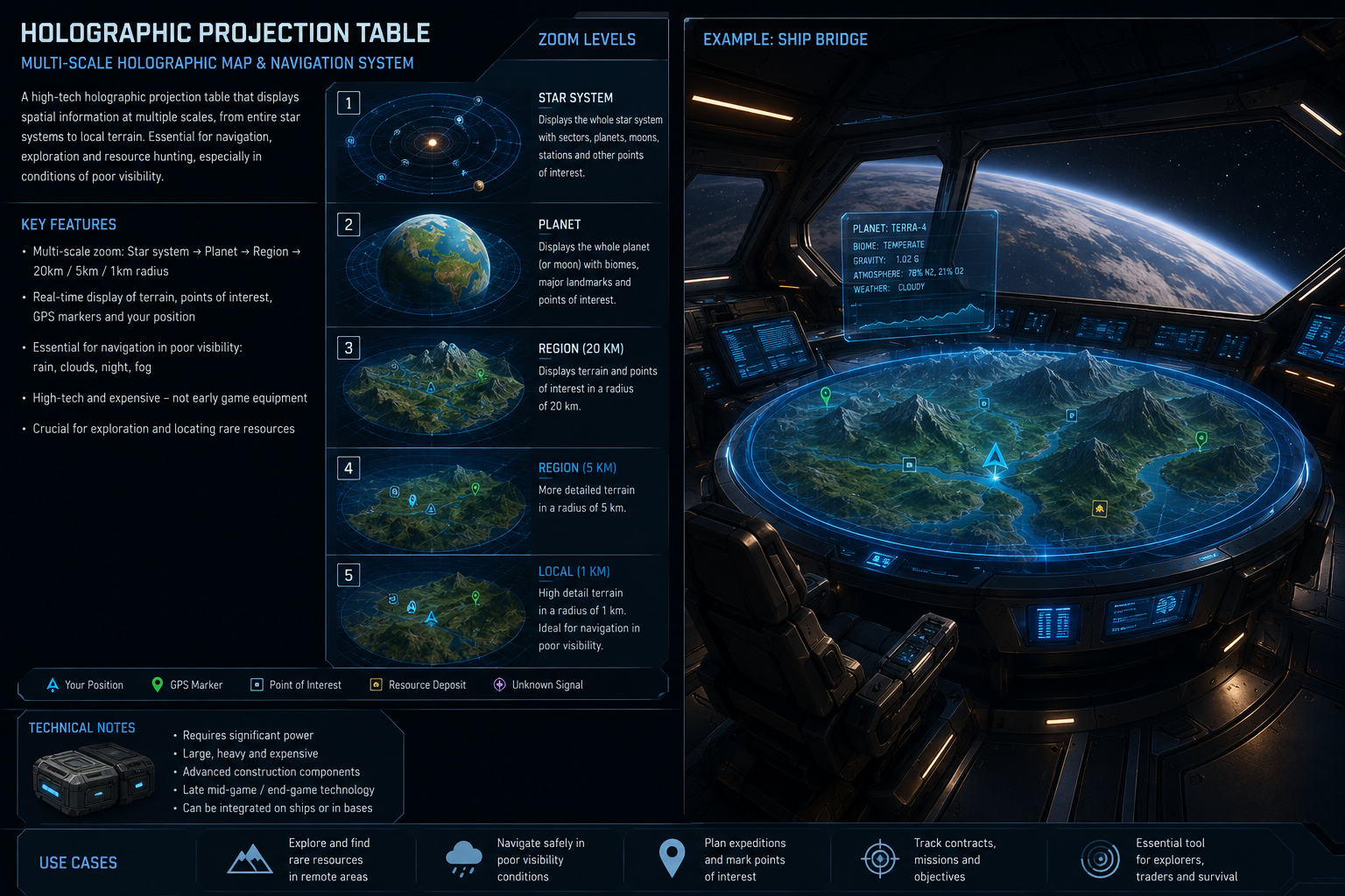
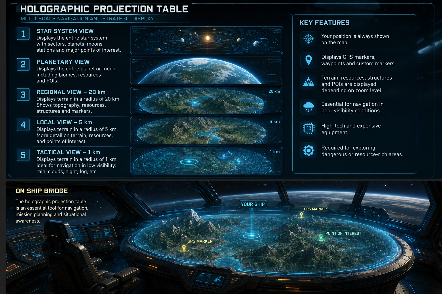
Holographic Projection Table
A high-tech holographic map for navigation, exploration and strategic planning.
Depending on the zoom level, it can display:
- The whole star system and sectors
- An entire planet or moon
- Local terrain at 20 km, 5 km and 1 km ranges
The highest zoom levels could provide detailed terrain information even in poor visibility conditions such as night, fog, rain or clouds.
 I like this feedback
 You can't vote. Please authorize!
Wow, 10x map !
My thoughts on limits, the map and the territory.
A map can show historical data of explored or shared information.
A map can add current information based on sensors, incoming communications and computer assisted enhancements.
Computers can add predictions to changes on the map relating to features and objects, based on analysis and modelling. The trajectory of a moving object at speed may estimate a time period to enter a given zone. 3d models of installations could be added to a map based on espionage data.
Wow, 10x map !
My thoughts on limits, the map and the territory.
A map can show historical data of explored or shared information.
A map can add current information based on sensors, incoming communications and computer assisted enhancements.
Computers can add predictions to changes on the map relating to features and objects, based on analysis and modelling. The trajectory of a moving object at speed may estimate a time period to enter a given zone. 3d models of installations could be added to a map based on espionage data.
Deon, you made me thinking more about it :)
Two important things: Scanners and Datapads.
Ofc, we need scanners. For now we basically have only one scanner, the ore detector. For all other kinds of exploration, we have pretty much nothing.
A special scanner could be used for long-range detection of resources or other features, like anomalies or the presence of dense asteroid clusters. Imagine you are searching for an all-ice asteroid. The only option right now is to visually inspect all the asteroids. Come on, we have technology in this world. Why can't we scan for water from longer ranges?
Now back to the main topic, how do you "fill" the map data? With a scanner, ofc. You store it on a datapad.
Different tiers of scanners could gather different levels of detail and cover different scales of the map. A basic scanner could map big celestial bodies like planets and asteroid clusters. A more advanced scanner could save a detailed terrain information and grids to a datapad.
One datapad could hold map data for one planet, but only for the regions you have actually explored. This would be very similar to how maps work in Minecraft, but instead of paper we use datapads.
The map block could use all datapads in the grid's inventory to display already explored regions. One datapad per planet seems like a good compromise between granularity and meaning. I hate micromanaging hundreds of maps in Minecraft. Here you would have one single datapad that can hold small portion of the planet map or an entire planet. For simplicity, the map data is not a copy but a reference to a single voxel data of the game, and you can ofc see only explored regions, so the real saved data is only an information about what you have explored.
And ofc, GPS points could be saved on map datapads instead of being stored in some virtual account of the engineer. You need to turn back alive with information you gather. You can't just fly around and save GPOS points then die and magically preserve all the information.
Those datapads containing map data would become interesting items on their own. You could find them as loot, with a portion of a map and/or a GPS point to some interesting location. You could buy certain types of maps from NPC stations and trade maps between players. Cartographer would actually become a real profession in the game :)
In order to copy map data, you could use a special "cartographer" computer block. Put one datapad on the left and another on the right and press copy. On the right, you could have either an empty datapad or a datapad with another map of the same planet and scale. This way you could merge multiple exploration maps into one.
Same for star system map. It is a single datapad to which you add planets, moons, asteroid clusters, sectors, and other kinds of areas. You will need only one for the entire star system. Copy and merge it same as for planet datapads.
Imagine multiple people or drones exploring the same planet/moon and then merging all their maps together.
The scanner would write data to a datapad that is currently in its inventory. It has several actions you can add to a hotbar: start mapping, stop mapping, add a GPS point at current location (an optional popup where you can insert a name/icon), take another empty datapad (will expel current datapad from its inventory and grab new empty datapad from a connected inventory if able).
The map block would be able to use all map data across all datapads in all connected inventories, including data that is currently being written by a scanner. It would basically work like a map atlas that automatically "manages" all the maps for you for display purposes, allowing you to see your current position on the map and navigate into different regions, zoom in and out. So there are following actions for you to use on a hotbar: zoom in, zoom out, move left/right/up/down, focus on your current position. From a star system map you can zoom in and pan around, if you zoom enough onto a planet or a moon, you will automatically pass to the planet map.
This is how you could immediately see the terrain around you while using a scanner in real time and safely navigate in poor visibility conditions.
Datapads should be first-class citizens in the game when it comes to storing all kinds of information. Maps, GPS points, blueprints, component blueprints and so on.
Deon, you made me thinking more about it :)
Two important things: Scanners and Datapads.
Ofc, we need scanners. For now we basically have only one scanner, the ore detector. For all other kinds of exploration, we have pretty much nothing.
A special scanner could be used for long-range detection of resources or other features, like anomalies or the presence of dense asteroid clusters. Imagine you are searching for an all-ice asteroid. The only option right now is to visually inspect all the asteroids. Come on, we have technology in this world. Why can't we scan for water from longer ranges?
Now back to the main topic, how do you "fill" the map data? With a scanner, ofc. You store it on a datapad.
Different tiers of scanners could gather different levels of detail and cover different scales of the map. A basic scanner could map big celestial bodies like planets and asteroid clusters. A more advanced scanner could save a detailed terrain information and grids to a datapad.
One datapad could hold map data for one planet, but only for the regions you have actually explored. This would be very similar to how maps work in Minecraft, but instead of paper we use datapads.
The map block could use all datapads in the grid's inventory to display already explored regions. One datapad per planet seems like a good compromise between granularity and meaning. I hate micromanaging hundreds of maps in Minecraft. Here you would have one single datapad that can hold small portion of the planet map or an entire planet. For simplicity, the map data is not a copy but a reference to a single voxel data of the game, and you can ofc see only explored regions, so the real saved data is only an information about what you have explored.
And ofc, GPS points could be saved on map datapads instead of being stored in some virtual account of the engineer. You need to turn back alive with information you gather. You can't just fly around and save GPOS points then die and magically preserve all the information.
Those datapads containing map data would become interesting items on their own. You could find them as loot, with a portion of a map and/or a GPS point to some interesting location. You could buy certain types of maps from NPC stations and trade maps between players. Cartographer would actually become a real profession in the game :)
In order to copy map data, you could use a special "cartographer" computer block. Put one datapad on the left and another on the right and press copy. On the right, you could have either an empty datapad or a datapad with another map of the same planet and scale. This way you could merge multiple exploration maps into one.
Same for star system map. It is a single datapad to which you add planets, moons, asteroid clusters, sectors, and other kinds of areas. You will need only one for the entire star system. Copy and merge it same as for planet datapads.
Imagine multiple people or drones exploring the same planet/moon and then merging all their maps together.
The scanner would write data to a datapad that is currently in its inventory. It has several actions you can add to a hotbar: start mapping, stop mapping, add a GPS point at current location (an optional popup where you can insert a name/icon), take another empty datapad (will expel current datapad from its inventory and grab new empty datapad from a connected inventory if able).
The map block would be able to use all map data across all datapads in all connected inventories, including data that is currently being written by a scanner. It would basically work like a map atlas that automatically "manages" all the maps for you for display purposes, allowing you to see your current position on the map and navigate into different regions, zoom in and out. So there are following actions for you to use on a hotbar: zoom in, zoom out, move left/right/up/down, focus on your current position. From a star system map you can zoom in and pan around, if you zoom enough onto a planet or a moon, you will automatically pass to the planet map.
This is how you could immediately see the terrain around you while using a scanner in real time and safely navigate in poor visibility conditions.
Datapads should be first-class citizens in the game when it comes to storing all kinds of information. Maps, GPS points, blueprints, component blueprints and so on.
Replies have been locked on this page!